
Fáìlì:Map of federal states.svg

Size of this PNG preview of this SVG file: 800 × 411 pixels. Àwọn ìgbéhàn míràn: 320 × 164 pixels | 640 × 329 pixels | 1,024 × 526 pixels | 1,280 × 657 pixels | 2,560 × 1,314 pixels | 863 × 443 pixels.
Fáìlì àtìbẹ̀rẹ̀ (faili SVG, pẹ̀lú 863 × 443 pixels, ìtòbi faili: 1.48 MB)
|
|
Fáìlì yìí wá láti Wikimedia Commons. Àròyé láti ojúewé ìjúwe rẹ̀ níbẹ̀ nìyí nísàlẹ̀. |
Àkótán
| Ìjúwe |
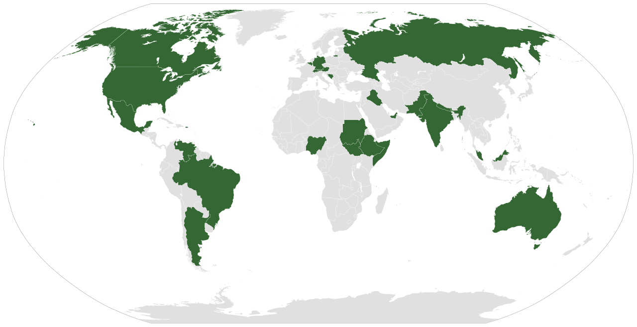
English: A map displaying today's federations.
Italiano: Una mappa mostrante le federazioni di oggi.
Русский: Современные федеративные государства на карте мира
Vèneto: Na mapa che mosa le federazion de incoi.
Español: Un mapa que muestra las federaciones que existen hoy.
Português: Um mapa que mostra as federações de hoje em dia.
Deutsch: Eine Weltkarte mit Hervorhebung aller föderaler Staaten. |
| Ọjọ́ọdún | |
| Orísun | Iṣẹ́ onítọ̀hún (Original text: Own work based on: File:BlankMap-World6.svg and the list in en:Federation#Contemporary. Coloured similar to File:Federal states.png) |
| Olùdá | Lokal_Profil |
| Àwọn àtẹ̀jáde míràn | File:Map of unitary states.svg and File:Map of unitary and federal states.svg |
| SVG genesis |
Ìwé àṣẹ
Fáìlì yìí wà lábẹ́ ìwé àṣẹ Creative Commons Ìdálórúkọ-Share Alike 2.5 Gbogbogbò.
Ìdálórúkọ: Lokal_Profil
- Ẹ ní ààyè:
- láti pín pẹ̀lú ẹlòmíràn – láti ṣàwòkọ, pínkiri àti ṣàgbéká iṣẹ́ náà
- láti túndàpọ̀ – láti mulò mọ́ iṣẹ́ míràn
- Lábẹ́ àwọn àdéhùn wọ̀nyí:
- ìdárúkọ – Ẹ gbọdọ̀ ṣe ọ̀wọ̀ tó yẹ, pèsè ìjápọ̀ sí ìwé-àṣe, kí ẹ sì sọ bóyá ìyípadà wáyé. Ẹ le ṣe èyí lórísi ọ̀nà tó bojúmu, sùgbọ́n tí kò ní dà bii pé oníìwé-àṣe fọwọ́ sí yín tàbí lílò yín.
- share alike – Tó bá ṣe pé ẹ ṣ'àtúndàlú, ṣàyípadà, tàbí ṣ'àgbélé sí iṣẹ́-ọwọ́ náà, ẹ lè ṣe ìgbésíta àfikún yín lábẹ́ ìwé-àṣẹ kannáà tàbí tójọra mọ́ ti àtilẹ̀wa.
Ìtàn fáìlì
Ẹ kan kliki lórí ọjọ́ọdún/àkókò kan láti wo fáìlì ọ̀ún bó ṣe hàn ní àkókò na.
| Ọjọ́ọdún/Àkókò | Àwòrán kékeré | Àwọn ìwọ̀n | Oníṣe | Àríwí | |
|---|---|---|---|---|---|
| lọ́wọ́ | 12:43, 3 Oṣù Ṣẹ̀rẹ́ 2023 | | 863 × 443 (1.48 MB) | Maphobbyist | Iraq and the United Arab Emirates are federal states. |
| 19:04, 21 Oṣù Òwéwe 2022 |  | 863 × 443 (1.48 MB) | Salma3232 | Reverted to version as of 03:24, 1 August 2021 (UTC) | |
| 12:00, 3 Oṣù Ògún 2021 |  | 863 × 443 (1.45 MB) | Siirski | Added Somaliland | |
| 03:24, 1 Oṣù Ògún 2021 |  | 863 × 443 (1.48 MB) | Waberi4291 | Reverted to version as of 05:02, 8 September 2013 (UTC) | |
| 05:05, 8 Oṣù Òwéwe 2013 |  | 863 × 443 (1.48 MB) | EmmaCoop | Forgot Iraq | |
| 05:02, 8 Oṣù Òwéwe 2013 |  | 863 × 443 (1.48 MB) | EmmaCoop | Divided Sudan and South Sudan (became a state in 2011). | |
| 21:02, 26 Oṣù Òwéwe 2012 |  | 940 × 477 (1.65 MB) | Middayexpress | added Federal Republic of Somalia | |
| 17:29, 16 Oṣù Ògún 2008 |  | 940 × 477 (1.65 MB) | Jeroen | removed kingdom of the netherlands - see talk | |
| 00:18, 26 Oṣù Òwéwe 2007 |  | 940 × 477 (1.56 MB) | Lokal Profil | Less broken code and corrected metadata | |
| 01:34, 14 Oṣù Òwéwe 2007 |  | 940 × 477 (1.56 MB) | Lokal Profil | Readded netherlands, aruba and netherlands antilles. See comment |
Ìlò fáìlì
Ojúewé kan yìí únlo fáìlì yí:
Ìlò fáìlì káàkiri
Àwọn wiki míràn wọ̀nyí lo fáìlì yìí:
- Ìlò ní af.wikipedia.org
- Ìlò ní als.wikipedia.org
- Ìlò ní an.wikipedia.org
- Ìlò ní ar.wikipedia.org
- Ìlò ní arz.wikipedia.org
- Ìlò ní ast.wikipedia.org
- Ìlò ní azb.wikipedia.org
- Ìlò ní az.wikipedia.org
- Ìlò ní az.wiktionary.org
- Ìlò ní ba.wikipedia.org
- Ìlò ní be-tarask.wikipedia.org
- Ìlò ní be.wikipedia.org
- Ìlò ní bg.wikipedia.org
- Ìlò ní br.wikipedia.org
- Ìlò ní bs.wikipedia.org
- Ìlò ní ca.wikipedia.org
- Ìlò ní ckb.wikipedia.org
- Ìlò ní co.wikipedia.org
- Ìlò ní cs.wikipedia.org
- Ìlò ní cy.wikipedia.org
- Ìlò ní de.wikipedia.org
- Ìlò ní de.wiktionary.org
- Ìlò ní diq.wikipedia.org
- Ìlò ní el.wiktionary.org
- Ìlò ní en.wikipedia.org
- Ìlò ní eo.wikipedia.org
- Ìlò ní es.wikipedia.org
- Ìlò ní eu.wikipedia.org
- Ìlò ní fa.wikipedia.org
- Ìlò ní fi.wikipedia.org
- Ìlò ní fr.wikipedia.org
Ìfihàn ìlò míràn púpọ̀ fún fálì yìí.